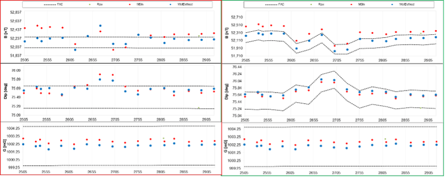
CHALLENGE
Surveys failed acceptance criteria, bringing into question the well positioning and the MWD tool reliability. The client had little appetite for the higher risks of a larger EOU and little time to troubleshoot the suspect MWD tool. The client was requesting a trip out to change the MWD
SOLUTION
Upgrading to WellDefined IFR2 survey services to account for ongoing magnetic storm was recommended.
RESULTS
Application of WellDefined IFR2 services brought surveys into FAC, allowing the client to continue drilling with confidence in wellbore positioning. The geological target was hit and the confirmed EOU will provide room for future drilling campaigns without unnecessary anti-collision risk.
MWD Surveys Unexpectedly Failing Acceptace Criteria
While drilling in the production section, attempting to maintain position in the target formation, the Measurement-While-Drilling (MWD) Surveys started failing quality acceptance criteria (FAC) due to magnetic interference, bringing uncertainty in the wellbore positioning. The FAC are based on comparing MWD measurements to a known Reference Model, with an acceptance range based on uncertainties in the measurements and the model itself as defined by industry performance models (IPM), which also statistically define the wellbore position using an Ellipse of Uncertainty (EOU). The issue was not drill string interference, as even after multi-station (MS) solution was applied the surveys still failed FAC. External interference from nearby well casing or lost-in-hole steel components (fish) was unlikely, as there were no nearby boreholes. Another source that was ruled out was a correctible MWD sensor failure. The client required high accuracy wellbore positioning and was prepared to trip out of hole and replace the MWD tool, a timely and costly undertaking on an offshore rig.
Ongoing Solar Storms- Compensate With WellDefined IFR2
Nearby magnetic observatories were checked, shown in Figure 1. This indicated ongoing solar activity that aligned with the MWD surveys. The WellDefined IFR2 service was recommended to the client. The service uses this magnetic observatory information to update the FAC and to directly adjust the magnetic declination that corrects magnetic azimuth, as measured by the MWD tool, to true north azimuth, and ultimately to grid north azimuth, which allows wellbores across an area to be consistently mapped. The client agreed, and real-time corrections to the surveys were applied, allowing the run to complete successfully while maintaining high confidence in the wellbore positioning.

